This short version of the report on
Architectural and Archaeological Studies at
Ile de la Passe, Mauritius - The 2005 Season of Fieldwork,
is requested by the Earthwatch Institute,
the main sponsor of the 2005 season, and has been prepared for them, for other sponsors or potential sponsors,
for participants and for all those interested in the project.
The report has benefited greatly from discussions with Miss Jayshree Mungur,
Research Coordinator of the Aapravasi Ghat Project and Liaison Officer for the National
Heritage Fund, who freely shared her unparalleled knowledge of recent archaeological
investigations in Mauritius.
Digital versions of these annual reports for sponsors,
prepared since 2003, are available on the web at
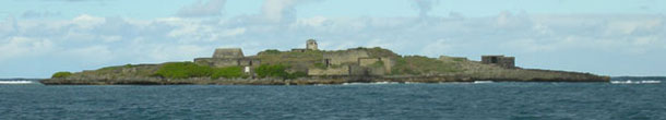
Maps of Ile de la Passe
The topographic survey commissioned by the NHT from A. S. Calloo,
sworn surveyor, in 2002 provides the base map for all studies. Ten stations set in concrete form
the reference points for current and future surveying. The map itself is tied to
the National Grid of Mauritius. An arbitrary height of 100m above sea level was given to Station A.
This map was updated after the 2004 season of fieldwork,
most notably by the addition of Structures 32 and 33. In 2005 the West Ditch was added
(Fig. 6).
Several old maps from different archives continue to be used in our research,
in particular for studies related to the chronological development of defences and structures on the islet.
|